Thursday, August 23, 2012

Finding the Path


Today was a great day.  It was the first of four sols (martian days) that I am assigned to the tactical Long Term Planner (LTP) role, which means I attend meetings and am generally responsible for communicating LTP decisions to the relevant people.  

It was also a hard day.  The team has been working hard to find the right order and timing of activities over the next few sols.  The LTPs have been making sol trees showing the various choices, considering the engineering constraints, and trying to optimize the outcomes of various necessary activities.  The decisions were so complicated that we have had more than two significant plan revisions per sol for several sols.  We finally found the right order for things just in time for solorrow (tomorrow's sol)!  We knew it was right when each person we consulted provided more insights that supported the new plan rather than requiring changes.  Whew!  

At the end of my shift, after writing my notes, I send an e-mail updating a number of people on the new plan for Sol 19 (solorrow).  One of the instrument Principle Investigators thanked me for my patience, and here is my response:

I don't feel like it was so much patience as finally feeling the path under our feet.  In the late 1980's, I went on a hike up Mt. Baldy (just to the east of us here in Pasadena) and started to watch the sunset from the top with some friends.  Then we realized that none of us had flashlights.  We ran down as fast as we could with the remaining daylight.  Then it got dark and we got to a wooded area.  We lost the trail.  I stayed in place while my friends when off in different directions looking for the trail.  My philosophy was that I must be really close to the trail as one can't go very far off the trail in the dark.  It turned out that it was only a foot to my right.  Today was like that.  We've been running around, trying to find the right path.  Suddenly, things came together, and we got back on it.  There is still a lot of work to get down off the mountain, but we have a plan that will keep us moving forward.  I really like days like today...

For my next birthday, soon after that mountain trip, my dad gave me a day pack with a matching flashlight.  I've almost always had a flashlight with me since then.

And reading my response now, I think I should say "There is still a lot of work to get to the mountain" since Curiosity is not yet even at the base of the trail up.  Mt. Sharp is beautiful and it calls my spirit of adventure!

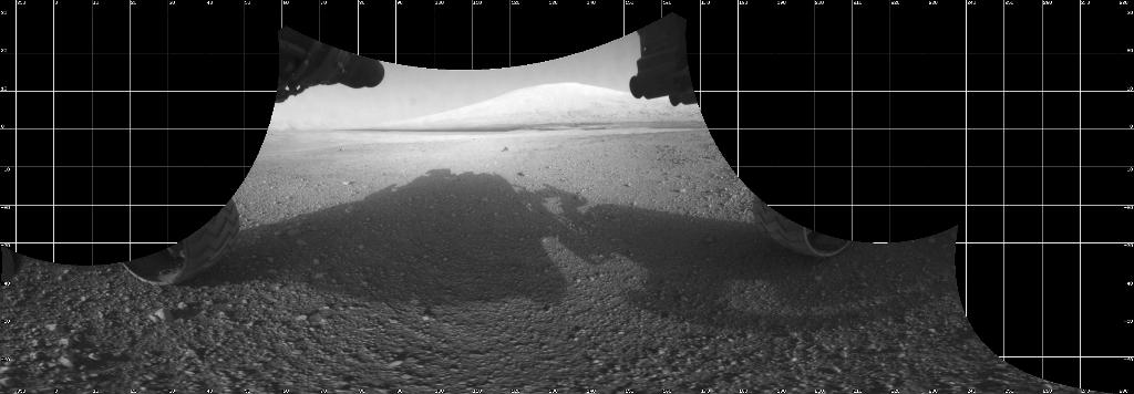
HazCam mosaic of Curiosity's shadow and Mt. Sharp.
Photo Credit: NASA/JPL-Caltech

Friday, August 17, 2012

First Day Off...

I took my first day off in almost 3 weeks!  I actually did a bit of work first thing in the morning, but then I managed not to read my Curiosity-related e-mail all the rest of the day.  I managed this by sticking to places with low bandwidth!

On my day off, I:
1) paid my bills and went to the bank;
2) did some UCD-related work;
3) went shopping - I found what will be my favorite store: El Super.  It has all sorts of interesting foods, including fresh garbanzo beans (a first for me) and a dozen corn tortillas for 39 cents!
4) slept
5) read Solaris by Stanislaw Lem - Science Fiction seems appropriate to read right now!
6) cooked a stew of buffalo, onions, poblano peppers, anaheim peppers, bell peppers, fresh garbanzo beans, zucchini, and spices including two types of dried chili.
7) cleaned house
8) failed to get my car smog checked - only a minor problem; all the places were too busy, and I had groceries in the trunk.

I spent most of the day in my apartment, which is charming.

The "dining"room.  The front door is down the stairs on the left.  The kitchen is to the right.

My living room couch is a TV stand covered with a camping pad and a Pendleton blanket.  The pillows provide the back.  It is surprisingly confortable, and I've actually even fallen asleep on it once!
I almost always end up sitting in this rocking chair, looking out to the NNW.  The chair is comfortable, and the view is amazing!  I have a large table-like desk to the left, where I also end up working.  However, my wireless connection isn't very good, so I end up doing e-mail, etc. in the walking closet next to a window there!
The view from my rocking chair.  This is looking out to the mountains just north of Malibu.  I don't know their name.  Catalina Island is often visible, but is almost entirely encased in the "marine layer" clouds in this image.  Griffith Park is behind the tree on the left.

Saturday, August 11, 2012

Be on Mars!

There are some very cool martian toys available that can give you a real sense of being with Curiosity on Mars.  First, you need to know what time it is, so you should get a Mars24 Sunclock.  When MSL is in the dark, we're hard at work!


Next, you can land with Curiosity at Eyes on the Solar System by choosing "replay".  Then there's the "LIVE Mode" button that you can use to follow along on our mission!  The simulation that you see was scripted before landing and was only 0.6 seconds off in time.  They didn't get exactly the right landing site, though.  This will be corrected in the next week or so.  I think that the site will follow Curiosity during the entire mission!  What fun!

Friday, August 10, 2012

Quad 51: Yellowknife

I had a bit of fun yesterday...  I participated in a JPL press conference, and I was supposed to describe our mapping work on the team, which I've been co-chairing with John Grant. Fred Calef is doing all the hard work.  This effort has been going on for about a month before landing.  We solicited volunteers from the science team to each map a 1.3x1.3 km quad in or near the landing ellipse.  The volunteers submitted their maps, and we've been integrating them into a single map.  In our mission work, we are refining our efforts and developing models for how the different rock types formed.  It's been an amazingly fun project.

In addition to describing the mapping effort, I was going to announce the name of the quad we landed in - it happened to be one of the ones I mapped.  However, at the last minute, we decided to postpone the announcement.  Thus, I talked about Quad 51.  No one on the team had noticed - or at least said anything - about this coincidence.  Immediately, the press, however, picked up on "Area 51".  We landed in Area 51!  Total coincidence!

The name Yellowknife was announced after the press conference.  That now has people running around explaining why we chose Yellowknife, which I had planned to do in the press conference!  So here's a bit about why:

For the Geologists:  The Yellowknife Supergroup consists of rocks that are about 2.7 billion years old.  They form a greenstone belt (Sasha and the UCD Geology Club - they include one schist, two schist, green schist, but no blue schist.) that overlies the oldest rocks in the world, the 4.98 billion year old Acasta Gneiss.

For the Historians and Geologists, who are after all, historians of the earth:  Yellowknife is the largest town in the Northwest Territories with a population of a little less than 20,000 people.  It is named after the Yellowknife Dene who live in the area and used to make knives out of copper.  In the 1930's, Yellowknife was a gold and uranium boom town, and in the 1990's it was the center of a diamond rush.  Many geologists and arctic explorers go through Yellowknife on their way north.  Thus, the town holds many interesting memories for a number of people on the team, including John Grotzinger, the Project Scientist, who is the one who chose the name.

Congratulations to Yellowknife!

Back to the topic of Area 51: The team loves it, as do the engineers.  In today's press conference, one of them talked about all the strange things that happened in Quad 51.  It couldn't have been better!

Tuesday, August 7, 2012

Great Mashup Video of Landing

Watch and enjoy!


During landing, I was watching the plot of doppler shifts for Curiosity's tones, sent direct to earth.  The doppler shift says how fast the spacecraft was moving relative to earth.  I saw a sudden drop in doppler shift, just before they announced the parachute deploy - it was dramatic!  I knew immediately that the parachute was doing something because nothing else would slow down the decent that quickly.  Once earth set behind the crater rim, we no longer had a signal and relied on Odyssey for all "real-time" data.  That's one of the reasons there was so much cheering when we heard that Odyssey and Curiosity were talking.

Science, Science, Science!

The first MAHLI image came down!  This is our microscopic imager that can also focus at a distance.  This image was taken through the dust cover of MAHLI, and we kicked up a lot of dust on landing.  Thus, the image is not as sharp as we will see later in the mission.  However, it is really beautiful and reminds me of the Smokey Mountains!  Although the color is different - and this is true color, taken with an RGB imaging chip!  Welcome to Mars, the Red Planet - or maybe orangey-yellow planet.  Just wait until we get that dust cover off or the first pictures with the color MastCams!

Ken Edgett describing the first MAHLI image from Curiosity.  You can see a distinctive peak on the crater rim!  This image reminds me of the Smokey Mountains!  Although the color is a bit different - Welcome to Mars, the Red Planet!  From AP Photo.


The science efforts are really heating up.  We've been working on mapping the geology and geomorphology of Curiosity's landing area using data from orbiters.  These data are amazing!  And when you have a hundred people looking at the same areas, lots of observations get made.  I've worked with several others to compile maps made by ~20 volunteers.  We are now at the stage of identifying better units for one of the particularly interesting rock types.  We'll have a detailed discussion about how we want to map that unit starting at 1 am!  It's absolutely fantastic!

Monday, August 6, 2012

Color Movie of Landing on Mars

The MARDI camera took the very first movie of landing on Mars, and we got more than 100 thumbnail images back from it this morning.  It's in color!  We'll have higher resolution soon!

http://www.nasa.gov/multimedia/videogallery/index.html?media_id=149974611

We're there! And now it's time for SCIENCE

We landed!  It couldn't have been better or more successful!  Nothing (!!!) went wrong, except the A/V system in the Science Discussion room was stuck in "show NASA TV" mode from the landing.  We could still talk, though!

I finished my shift as Long Term Planner at 9:30 in the morning.  I went home and immediately fell asleep for 9 long hours.  I woke up just in time to watch the sunset.  In reading my e-mail, I've learned that we got a lot more data while I was out.  I'm eager to get back in, see where we landed, and dive back into the science.

UCDavis compiled a list of links to media coverage of me, which Louise sent around.  Here's that list:


Outlet: BBC News
Title: Gale Crater: Geological 'sweet shop' awaits Mars rover
Publication Date: 08/03/2012
Summary: BBC News interviews geology professor Dawn Sumner about the Mars rover mission: "I am confident we will learn amazing new things. Some of them will be answers to questions we already have, but most of what we learn will be surprises to us."
Unique Visitors Per Month: 8,696,910

Outlet: Nature
Title: Crater Mound a Prize and Puzzle for Mars Rover
Publication Date: 08/03/2012
Summary: Many researchers have differing theories regarding the formation of the mysterious Mount Sharp on Mars, but Dawn Sumner is not concerned with these differences. "That's what the mission is for," she says. "We have a million different opinions among 250 people."
Unique Visitors Per Month: 1,862,094

Outlet: Sacramento Bee
Title: Mars Rover Success Could Lift Future Missions
Publication Date: 08/05/2012
Summary: The Sacramento Bee interviews Dawn Sumner about the Mars rover mission: "It will be an adrenaline rush, but I tend to be an optimist." As co-investigator, Sumner is in charge of culling information from data sent back from the rover. "We will be looking for rocks that are 3 billion years old," she said.
Unique Visitors Per Month: 1,158,680

Outlet: Sacramento Bee
Title: Video: UC Davis Professor Dawn Sumner Speaks About the Mars Rover Mission
Publication Date: 08/05/2012
Summary: Before the Mars rover "Curiosity" landed on the planet Sunday night, UC Davis professor Dawn Sumner discussed its mission and landing.
Unique Visitors Per Month: 1,158,680

Outlet: Davis Enterprise
Title: UC Davis Scientist Prepares for Mars Rover Landing
Publication Date: 08/05/2012
Summary: Geology professor Dawn Sumner will spend the first four "Martian" days as the "long-term planner" of the Mars rover team, coordinating the first scientific interpretations of what is seen when the rover lands and helping make daily decisions about Curiosity's activities.
Unique Visitors Per Month: 17,332

Outlet: KCOP-TV
Title: Fox News at 11
Air Date: 08/05/2012
Summary: Fox 11 was at the Jet Propulsion Laboratory in Pasadena, California where UC Davis geologist Dawn Sumner celebrated the successful Mars rover landing with her colleagues and discussed the mission's purpose.
Nielsen Audience: 32,410

Outlet: Hearst Television Inc.
Title: KCRA News
Air Date: 08/06/2012
Summary: Dawn Sumner was among the many viewers watching the Mars rover landing on Sunday night, preparing for her next four days of crucial work to uncover the scientific meaning of the rover's discoveries.
Nielsen Audience: 14,594

Outlet: Capital Public Radio
Title: Mars Rover Will Have UC Davis Professor at Controls
Publication Date: 08/02/2012
Summary: Dawn Sumner was picked for her position on the Mars mission because of her experience searching for life forms in Antarctica, the place on earth that may be most like Mars. Speaking with CPR, Sumner says the evidence of life her team is looking for is very, very small.
Unique Visitors Per Month: 16,016

Outlet: Planet Save
Title: Mars Rover Curiosity Will Explore Strange Crater
Publication Date: 08/05/2012
Summary: NASA's Mars Rover Curiosity is set to land on Mars and explore Mount Sharp, a 5.5-km-tall mound of layered sediments that time and pressure have squeezed into a mountain of rock, strangely located in the center of the large Gale crater. Dawn Sumner refers to it as a "scientific enigma."
Unique Visitors Per Month: 31,686

Outlet: Dawn on Mars (Professor Sumner's personal blog)
Title: How to do Science with 300+ Team Members and a Rover on Another Planet
Publication Date: 08/05/2012
Summary: Geology professor Dawn Sumner has written a blog post describing her work with the Mars rover "Curiosity" and the purpose of their mission.
Unique Visitors Per Month: N/A

Sunday, August 5, 2012

How to do Science with 300+ Team Members and a Rover on Another Planet


Space missions are special. They take hundreds of people cooperating over many years toward a common goal of success.  It’s a complicated process.  MSL is my first mission, and this is my perspective of how the process works.

There are innumerable interesting scientific questions one can ask about Mars, ranging from how it formed to how it has changed through time geologically to how it has changed through time climatically to the potential existence of life.  The first step in any mission is deciding which of those questions to investigate.  To help guide those decisions, NASA sponsors the Mars Exploration Program Analysis Group (MEPAG).  In addition to other activities, MEPAG maintains a document that outlines the science community’s consensus on the most important scientific questions to address in relationship to understanding Mars.  Any scientist interested in Mars can participate in MEPAG meetings and provide feedback to this “Goals Document”.  Based on the highest priority science investigations, NASA then commissions working groups to study particular mission types, for example an orbiter, a rover, or sample return.  They include evaluations of whether or not the desired science investigations are technically feasible and financially realistic.  Once potential missions are well enough defined, they are evaluated in the context of all of NASA’s planetary science missions by a committee established by the National Research Council.  This committee produces a “Decadal Survey” document, which outlines what NASA should plan for and accomplish within the field of planetary sciences in the next 10+ years.  If funding is available, the NASA Planetary Sciences Subdivision is required to take the appropriate steps to implement technology development, fundamental research, and missions with the priorities provided in the Decadal Survey.  

When a mission to Mars of a certain type and with general scientific goals is a high priority in the Decadal Survey, NASA commissions a large number of studies to define what is technically possible, what is scientifically reasonable, and what fits within the “budget wedge”, e.g. how much money per year over the next decade can be expected minus the amount per year that is already committed for other missions.  Eventually, a mission emerges that is defined by more specific scientific goals. A call for proposed instruments is released to the science community.  This call lays out what types of observations need to be made, how much money is available, limits on the power and weight for instruments, and many more technical details.  In the case of MSL, the call for instrument proposals included a call for imaging instruments (e.g. cameras).  Malin Space Science Systems proposed to build and operate several cameras, and I was on one of those proposals.  Once the proposals are submitted to NASA, a committee of experts evaluates each class of instrument and chooses those that they think are the best for the money and can actually be built - there are many instruments we want that are just too difficult to build so that they can be light enough and low power enough to go on a rover AND work at freezing Mars temperatures AND actually produce good results.  When the proposals are chosen, the selected teams get money to implement what they promised.  Our camera proposal was chosen.  
Problems come up.  Problems are solved.  Designs are changed.  Things are removed.  Things are added.  It has taken 8 years to go from the selection of proposals to the launch of MSL!  (It was actually delayed by 2 years due to some technical problems that emerged in the detailed design, implementation, and testing of the rover.)  

While the engineers are building the rover and instruments, the scientists are learning what the instruments can do, calibrating them, choosing where to land, dreaming up new hypotheses to test, etc.  Many individuals on the team are both engineers and scientists - they have a scientific question that they build an instrument to address, or they build an instrument and find science questions that can be addressed by their analyses.  Other team members are one or the other.  The thing we all share is a focus on mission success.  If the instruments fail, the scientists don’t get their data.  If there weren’t interesting science questions, the engineers wouldn’t have a cool rover to design, build, and test.  
We are now at that critical point where everything changes.  The hardware is all built and about to land on Mars.  The goal on MSL now is to operate the rover and its instruments as productively as possible on another planet.  Curiosity is a robot; every single action is controlled by software.  The software is designed to do some things on its own, like Entry, Decent, and Landing (EDL).  It has to be able to do that autonomously because, right now, it takes 14 minutes for a signal to go from Earth to Mars.  It only takes 7 minutes to land.  Thus, we can’t help Curiosity during EDL; she has to do it on her own.  However, once Curiosity is on the surface of Mars, things can go more slowly.  The team on Earth can decide what to have the rover do, and we can send commands up asking her to do different things each day.  

Putting the daily commands for Curiosity together is now our focus - this is called Operations.  Four times per martian day (called a sol), one of two orbiters around Mars will talk to Curiosity.  In the martian afternoon, the orbiters will receive data from Curiosity and in the martian morning, they will provide commands to Curiosity (and receive more data).  These data include the health of the rover, various essential engineering details, and scientific results.  As soon as these data are relayed back to Earth, the science and engineering teams pore over all the details.  If something is wrong with the rover, Tiger Teams are assembled to figure out what is actually wrong and how to fix it.  If nothing is seriously wrong, the science team uses the new data to plan observations for Curiosity to make the following sol.  Every single observation has to be requested.  For example, if you want to know if there is a rock nearby, you have to ask for a picture and wait a sol (or more) for that picture to come back and then look at it.  Since we need to know where we are, images are taken very frequently.  If we want to know the composition of that rock, it takes more planning.  If we have an image, we know where the rock is, and the ChemCam instrument can then be used to vaporize a bit of the rock with its laser.  It takes another sol to vaporize the rock and get that information back.  If we want more detailed results from the APXS instrument on the rover arm, the scientists have to decide where on the rock they want to analyze.  Then the engineers have to figure out how to move every joint on the arm to get the APXS instrument to that position safely.  If it can work, the scientists and engineers work together to make the detailed software commands that tell Curiosity how many turns of each motor and in what order to move for the instrument to end up safely in the right spot and then make the analysis.  Once everything is proofread and any new commands are tested on the twin rover in the “Mars Yard” at JPL, the commands are sent to Curiosity to execute.  As you can imagine, this takes time!

Every single sol, the engineers and scientists go through this process - making sure the rover is safe, deciding what to have Curiosity do, writing the commands that will be executed, proofreading them many times, and sending them off.  We call these “tactical” activities.  We have roughly 16 hours between the time we get data from Curiosity until it’s time to send up the next set of commands.  It takes a lot of people to do this well!  And the team will be doing it every sol for one Mars year (~2 Earth years)!

As you can imagine, it is easy to get caught up in the details.  However, we have those big science questions that NASA used to define the mission.  The mission has to address those questions; it has to stay on track and not spend all of its time looking at everything that might be interesting.  Thus, there is a management structure for “strategic” planning.  The people who led the instrument teams and a few people appointed by NASA make up a committee that sets the strategic timeline for the mission.  For MSL, the long-term goal is to investigate the rocks that make up Mount Sharp in Gale Crater.  Thus, the committee might give the guideline that the rover can characterize a particular set of rocks for 3 sols, but then has to move toward the main science target.  The tactical planning then has some long-term structure.

My first job in operations is as a Long Term Planner (LTP).  A LTP is assigned to work with the tactical process each sol.  Their job is to make sure the tactical process is consistent with the strategic guidelines.  For example, the LTP would intervene if the tactical planning started a set of analyses that would take 5 sols, but Curiosity was supposed to be moving on in 3 sols.  The LTP also makes sure that important discoveries made by team members during the tactical process get incorporated into the strategic plans.  For example, if those 5 sols of analyses were in response to the discovery of a new feature that was really important for the science goals, the LTP would make sure the guiding committee knew about the discovery, possibly suggesting modifications to the strategic plan.  In addition, the LTPs facilitate scientific discussions and interpretations.  After the activities for the next sol are chosen, the LTP leads a Science Discussion during which team members share the discoveries of the sol, plus discuss interpretations of data, new scientific hypotheses, possible investigations that should go into the strategic plans, etc.  This is a place for heated debates, consensus building, and new insights.  Finally, the LTPs are responsible for keeping track of many details such as things that got forced off the tactical plan due to power or time constraints but are really important, the names of sites and features, etc.  


It’s a great job!

Thursday, August 2, 2012

Greg says I'm famous...

One of my former students sent me an e-mail today with the subject line "now you're famous".  He found me in photo 3 on this web site.  It's actually a picture of John Grotzinger (Project Scientist) from the news conference announcing the choice of landing sites more than a year ago.  I do look impressed with what he's saying - or maybe with his strength at being able to hold up the rover at chest height with one hand.  Greg was exaggerating.

But here is the UCDavis news release from today (video filmed late last week), which might make me wildly famous among my friends:


The text for the UCD news release is here and Capital Public Radio did a short news item after an interview with me.

I also talked to Nature reporter Eric Hand today.  He will be blogging science news from the mission.  Keep an eye out for discussions of Gale geology here.

ADDITION:  Eric's news item is really nice!